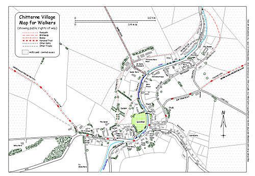
Saturday 29th January 2011 - Chitterne Walk Maps
The walking guides mentioned blog before last are up on the village website. Also village and parish rights of way maps (see village map above) and useful information about walking on military lands. I have created a new page "Walking in Chitterne" linked from the Leisure page via Village Life. You can go there from here.
Wednesday 19th January 2011 - Kneeler 5

This is the central part of the new altar rail kneeler being made to mark the 150th anniversary of Chitterne Church. It is being stitched by one person and therefore gives a better impression of the overall effect of the colours and the wonderful designs that AM has produced for us. Last Friday the second 9-foot long altar rail kneeler was set up in the hall for the first time alongside the first section. We are stitching every Friday through January and February. Two individual kneelers have been completed so far. We still have a long way to go.
Comment: It is great to see the colours so vivid, I guess in centuries gone by they saw a more colourful church than we do now. Magnificent, a project that will live for centuries. gg
Sunday 9th January 2011 - New Year, New Sign
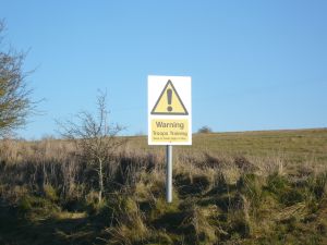
Happy New Year! This last week new "Troops Training Keep to Right of Way" signs have appeared around Chitterne on public rights of way. The one pictured here has been erected alongside Tyning Path, part of the Imber Range Perimeter Path that heads towards the FIBUA village on Copehill Down. There has been speculation amongst the many regular walkers as to why they have appeared just now. Is it to do with the big exercise we are expecting to take place at the end of January? Will they be taken down afterwards?
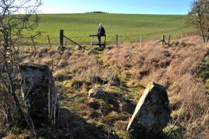
D has been out doing a lot of walking as part of his rehabilitation and as a result has created a series of local maps for walkers. There are ten so far. I am the guinea pig trying out his written instructions and maps. Today we walked number 7. A 6 mile circular loop, which took us from the Hollow to Quebec Farm, across the A390 heading towards the Codford road and back to Chitterne through the boundary stones, pictured, via the old water meadows. Some of the written instructions weren't clear enough, they needed more landmarks; in one place a fence had been removed, in another a cattle grid had been added. It wasn't possible to follow the correct path across one field because a crop was growing there so we took a longer route around the field's edge, and so on. This looks to be a job needing continuous monitoring. If you are a regular village walker you may find a packet containing the 10 walks pushed through your letter-box. A volunteer is needed to attempt to follow the instructions for the longest walk of 16 miles, any takers? When all the walks have been tested and passed I hope to add them to the Leisure page on the village website.
11 Jan: More signs have appeared since the above. The new signs are folded shut, but when opened the sign at Lima tank crossing, (next to the Pumping Station), says "Troops Training No Unauthorised Access".